NASA releases eye-popping view of carbon dioxide
Read the full article online at http://climate.nasa.gov
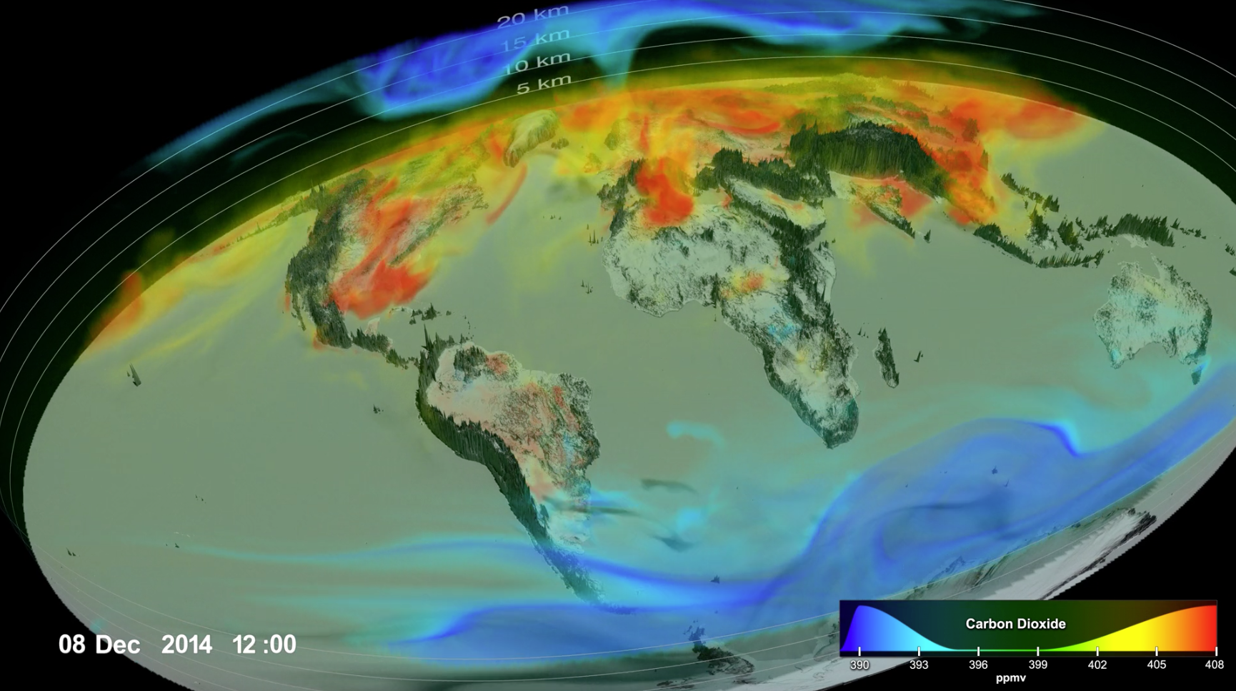 “A new NASA supercomputer project builds on the agency’s satellite measurements of carbon dioxide and combines them with a sophisticated Earth system model to provide one of the most realistic views yet of how this critical greenhouse gas moves through the atmosphere. Scientists have tracked the rising concentration of heat-trapping carbon dioxide for decades using ground-based sensors in a few places. A high-resolution visualization of the new combined data product – generated by the Global Modeling and Assimilation Office at NASA’s Goddard Space Flight Center in Greenbelt, Maryland, using data from the agency’s Orbiting Carbon Observatory-2 (OCO-2) satellite build and operated by NASA’s Jet Propulsion Laboratory in Pasadena, California – provides an entirely different perspective. The 3-D visualization reveals in startling detail the complex patterns in which carbon dioxide in the atmosphere increases, decreases and moves around the globe over the course of September 2014 to September 2015. Atmospheric carbon dioxide acts as Earth’s thermostat. Rising concentrations of the greenhouse gas, due primarily to the burning of fossil fuels for energy, have driven Earth’s current long-term warming trend. The visualization highlights the advances scientists are making in understanding the processes that control how much emitted carbon dioxide stays in the atmosphere and how long it stays there – questions which ultimately will determine Earth’s future climate.
Scientists know that nearly half of all human-caused emissions are absorbed by the land and ocean. The current understanding is that about 50 percent of emissions remain in the atmosphere, about 25 percent are absorbed by vegetation on the land, and about 25 percent are absorbed by the ocean. However, those seemingly simple numbers leave scientists with critical and complex questions: Which ecosystems, especially on land, are absorbing what amounts of carbon dioxide? Perhaps most significantly, as emissions keep rising, will the land and the ocean continue this rate of absorption, or reach a point of saturation? The new dataset is a step toward answering those questions, explained Lesley Ott, a carbon cycle scientist at NASA Goddard and a member of the OCO-2 science team. Scientists need to understand the processes driving the “carbon flux” – the exchange of carbon dioxide among the atmosphere, land and ocean, Ott said. “We can’t measure the flux directly at high resolution across the entire globe,” she said. “We are trying to build the tools needed to provide an accurate picture of what’s happening in the atmosphere and translating that to an accurate picture of what’s going on with the flux. There’s still a long way to go, but this is a really important and necessary step in that chain of discoveries about carbon dioxide.” OCO-2, launched in 2014, is NASA’s first satellite designed specifically to measure atmospheric carbon dioxide at regional scales.”
Read the full article online at http://climate.nasa.gov